

The Appalachian Trail (AT) is a 2160 mile
trail from Mount Katahdin, Maine to
Springer Mountain, Georgia. It was
conceived more than 75 years ago by Benton
MacKaye. Only about 1% of the trail runs
through "unprotected" areas. The AT is
marked along the way by 2"x6" white blazes
or mountaintop cairns. There are 3 sided
shelters built every 10 miles or so.
The AT is also extremely well known to the
local people and getting rides off-trail is
much easier. There are several "trail
angels". These are kindly folks who help
out along the trail by offering soft
drinks, water, food and assistance. It is
also called "trail magic". Some of the
trail angels have become quite legendary.
Every year about 3000 people attempt to
thru-hike the AT of which about 10%
succeed. About 80% are males. It draws from
an exceptionally wide range of professions,
a wide range of age groups (somewhat under
represented by the 30 to 40 age group), but
a narrow racial mix (very predominantly
white). There is good camaraderie along the
trail (especially north-bound) and it is
not uncommon to make life long friends
during a thru-hike.
Extensions are now being added to the AT
and the whole thing is called Eastern
Continental Trail. The north side has the
International Appalactian Trail (IAT) that
runs from Mount Katahdin, Maine to Park
Forillion, Quebec, Canada for a distance of
about 700 miles. The south is being
extended from Springer Mountain, Georgia to
Key West, Florida by the Benton MacKaye
(100 miles), Georgia Pinhoti (150 miles),
Alabama Pinhoti (150 miles) and Florida
National Scenic Trail (1000 miles). There
is also a significant roadwalk from the
Alabama Pinhoti trail to the Florida
National Scenic Trail (150 miles) ane form
the Florida National Scenic Trail to Key
West (150 miles). The entire trail is
approximately 4700 miles. The extensions
are relatively recent concepts and are not
as developed as the AT. Some sections run
along roads and most have no shelters. This
is the more adventorous portion of the
hike. There are also almost no hikers on
the non-AT trails. I averaged on average 1
hiker every 7 days or so here.
ECT Trail Map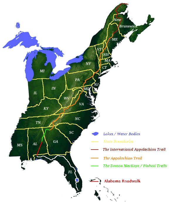
|
Logistics:
AT:
The AT has shelters every 10 miles or so. So
one can plan the day\'s hike to end at a
shelter and then sleep there. It also passes
near a town about every 5 days. So hikers
usually get their food and supplies during
town stops. In some instances the trail runs
through the town. More commonly, the hiker
will either have to walk or hitchhike a
little to get to the stores. One can thus
think of a multi-month thru-hike as a series
of 5 day hikes.
Non-AT:
The non-AT trails are much younger and thus
do not have the shelters or adequate maps or
information. (The AT is often criticized for
being over documented thus reducing the
element of adventure). The trials are not
well known, thus getting rides become more
difficult. Here you are on your own.

